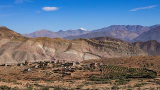

Imlil is the last village on the paved road into the High Atlas, about 60 to 70 km south of Marrakech and 1,740 to 1,800 m above sea level, depending on whose map you trust. This day starts with a shared taxi at 07:30, reaches the village centre around 09:15, walks up the valley to the terraced village of Aroumd, and then continues as far as Sidi Chamharouch, the shrine that most visitors on the Toubkal path reach first. You are back on the road by about 15:00 and in Marrakech around 17:00. It is a long day: about three hours in a car and four to five hours on foot, most of it on a wide mule track.
The order matters. The valley is in shade early, the walk up is easier before the heat, and the afternoon taxis back to Marrakech are easier to find while it is still light. If five hours of walking is too much, the same day works as a shorter walk to Aroumd and back with a long lunch, and both versions are set out below. What this day cannot be is a climb of Jebel Toubkal: the summit is a two-day trip from Imlil, explained further down.
 The Imlil valley seen from the path above the village, with terraced fields and walnut trees along the river. Image: DimiTalen, CC0, via Wikimedia Commons.
Before you go: the three things to sort out
- A licensed guide. The Toubkal route above Imlil is policed: guides are required for the trail to the refuge and summit, and checkpoints check your passport and your guide's ID. Reports on where exactly the first checkpoint stands vary, but several place it just outside Aroumd. Whether the short walk from Imlil to Aroumd itself needs a guide is not clearly stated in any source we could find, so treat a guide as necessary for anything beyond Aroumd, including Sidi Chamharouch. Licensed guides are hired at the guides' office in Imlil or through a guesthouse. Published rates for a day are 400 to 700 MAD (2025 and 2026 sources, one of them an operator's promotional page), and a short guided walk to Aroumd is quoted at 300 to 500 MAD. Ask to see the licence card.
- Your passport. Carry the original, not a photo. It is checked at the checkpoints.
- A way back. Shared taxis leave Marrakech when full, and the supply in the other direction thins out in the afternoon. We could not confirm a last departure time from Imlil. Plan to leave by about 16:00, or agree a return price with a private driver in the morning.
07:30 - Marrakech: finding the taxi
There is no train and no direct public bus to Imlil. The usual choices are these.
- Shared grand taxi. Six passengers, leaves when full, about 50 to 70 MAD per person according to a guide published in October 2026. The rank is the awkward part: sources place it near Jemaa el-Fnaa and Sidi Mimoun, or at the Bab er-Rob gate on the Tahanaout road, and it has moved before. Ask your riad the night before and expect to wait for the car to fill, sometimes half an hour or more. Some drivers only go as far as Asni, 17 km short of Imlil; the second leg is a local taxi or minibus at about 10 to 20 MAD.
- Private grand taxi. Quotes in 2025 and 2026 range from 250 to 950 MAD for the whole car one way, so agree the price before you get in. Kasbah du Toubkal publishes a private transfer at 90 euros per car, though its page is undated.
- Public bus to Asni. A local bus reaches Asni in about 1.5 hours (fare not confirmed), then a shared taxi covers the last stretch for around 10 MAD. It works but takes longer, and a day trip has little slack.
- A guided day tour. Operators sell transfers, a guide and lunch in a family home for roughly 60 to 80 euros per person for a small group. It removes the taxi puzzle and the guide question together.
The drive takes 75 to 120 minutes. The road is the R203: it runs south across the Haouz plain through Tahanaout, about 25 km out and with its own weekly market, then climbs through the gorge at Moulay Brahim, and reaches Asni after about 45 minutes. At the roundabout just past Asni you take the first left onto 17 km of tarmac up the valley to Imlil. On Saturdays Asni has its main weekly market, which slows the road and brings tour buses and touts. In the car park at Imlil, which charges a small fee if you drive yourself, the tarmac ends.
09:15 - Imlil: tea, a guide and a first look
Imlil is a working village of stone and earth houses with flat roofs, and it lives on mountain tourism: one guide puts the share of the population involved at more than 70 percent. The main street has cafés, shops selling water and bread, equipment rental (crampons and walking sticks can be rented), and the guides' office. Spend 30 minutes here: drink a first glass of mint tea, find your guide, buy water, and check the weather with whoever you hire.
The Toubkal National Park, created in 1942 and covering about 380 square km, begins above the village. Imlil lies at the foot of its main valleys, which is why every Toubkal climb starts here.
 Terraces and irrigation channels above Imlil, the farmland that the valley paths cross. Image: Richard Allaway, CC BY 2.0, via Wikimedia Commons.
09:45 - Imlil to Aroumd: walnut trees and the first view of Toubkal
The walk to Aroumd (also spelled Aremd or Armed) is about 2.5 km and climbs gently, on the order of 100 m. Allow 45 to 60 minutes with stops. The path leaves the main street, passes carpet and souvenir stalls, and then climbs steeply under walnut trees on a stone track before levelling out beside irrigation channels.
As the path rises you get the first view up the valley toward the Toubkal massif. Aroumd, at around 1,850 to 1,900 m, is a village built on a spur above the river, with flat-roofed houses stacked on the slope and fields dropping below.
 Aroumd stacked on its spur above the valley, with the High Atlas ridge behind. Image: Macabe5387, CC BY-SA 4.0, via Wikimedia Commons.
Many people turn around at Aroumd. If that is you, jump to the shorter version below.
10:45 - Aroumd: what you are walking into
Aroumd is a village where people live, not a viewpoint. Houses are family homes, children are on the paths, and the mule track through the middle is a working road. Take a glass of tea at one of the riverside cafés or guesthouses here if you want one; this is also where hospitality starts. You will be invited into someone's home, or be offered tea by a guide's family. Accepting is the normal response. Shoes come off at the door if others have removed theirs, and you drink the tea slowly, without hurrying to leave. A tip to a guide or host for lunch is customary.
A few rules apply everywhere in the valley. Cover shoulders, chest and knees: this is a rural, conservative area, and clothes that pass in the Marrakech medina can feel out of place here. Ask before photographing a person, and particularly a woman. A landscape needs no permission; a face does. Do not photograph the interiors of homes unless invited.
The 2023 earthquake hit villages like this one harder than Imlil, because older stone and earth construction is more vulnerable. Some houses you pass may be damaged or under repair. Walk past them quietly and do not use rebuilding as a photograph.
 Aroumd on its ridge in winter light, with snow on the peaks above. Image: Kitetraveller.com from Vienna, Austria, CC BY-SA 2.0, via Wikimedia Commons.
11:00 - Aroumd to Sidi Chamharouch: the mule track
Beyond Aroumd the route is the guided one: the checkpoints and the guide rule apply from here, so have your guide with you before you leave the village. The track follows the river bed up the valley toward the Toubkal refuge, wide enough for mules, with rock slopes on one side and the river on the other. It climbs, but it is a track and not a scramble. Expect walkers heading for the refuge and mules carrying their bags, and give the mules the inside of the path. A mule load comes first; if you meet one, step uphill.
Plan about two hours from Imlil to Sidi Chamharouch if you move steadily. Guides give about five hours as the round trip including stops, and one guidebook says six. Sidi Chamharouch sits at about 2,310 to 2,350 m, which means you gain roughly 550 to 600 m from Imlil. If you feel the altitude (headache, nausea), turn around without argument; you are not near the summit and nothing is forfeited.
 A waterfall on the Oued Rheraya in the Imlil valley, one of the water features along the river. Image: Alexander Klink, CC BY 4.0, via Wikimedia Commons.
A waterfall falls beside the shrine itself, and a guide may also point out smaller cascades on the way; one guide lists a cascade about 30 minutes from Imlil, though sources disagree on which falls are which and when they run. In dry months, some are thin.
11:45 - Sidi Chamharouch: look, but do not cross
Sidi Chamharouch is a pilgrimage shrine, built around a large whitewashed boulder, associated in local tradition with a saint known as the king of the jinn. The site is sacred to Muslims, and non-Muslims do not cross to the shrine itself; the chapel is open only to Muslims. You can see it from the near side of the river. Do not photograph pilgrims or people at prayer, do not try to enter, and do not treat a guide's explanation as a cue to ask for a closer look.
Allow 30 minutes. This is where most day walkers turn around. The path goes on to the Toubkal refuge, about 3,200 m up, which is where Toubkal climbers sleep. A day visitor going on from here is not on a day trip any longer.
 The Imlil valley in spring, with a stream running below snow-capped peaks. Image: Elh.yassine, CC BY-SA 4.0, via Wikimedia Commons.
12:15 - Back down to Aroumd for lunch
The descent takes about 75 minutes to Aroumd. Lunch here is simple: tagine or eggs and bread at a café or guesthouse, around 13:30. If you want to eat in a family home, ask your guide to arrange it in advance, and agree the price first.
You can ride a mule for part of the way if your knees complain. One operator quotes 100 to 150 MAD for a mule per day, but this is a promotional page, so settle the price and the distance with the muleteer before you sit down.
14:30 - Imlil again and the way home
The last 2.5 km back to Imlil take about 30 to 40 minutes downhill. Buy a bottle of water, pay your guide, and find your taxi by about 15:00 to 16:00. In a shared car, you will again wait for it to fill. By 17:00 to 17:30 you should be at your Marrakech rank. In winter the light goes early and the valley cools fast, so do not let the departure slip.
 Mountains above Imlil, the slopes the valley walks climb toward. Image: William Whyte from Dublin, Ireland, CC BY-SA 2.0, via Wikimedia Commons.
If five hours is too much: the Aroumd half-day
Walk to Aroumd (about 45 to 60 minutes), have tea, then return by the other side of the valley for a total of two to three hours on foot, as operators describe their day trips. Lunch at Aroumd, then the taxi back by 14:00 or 15:00. This version suits children and anyone with sore knees. Guide cost for the shorter walk is lower, about 300 to 500 MAD in one operator's quote.
The day at a glance
| Time | Stop | Allow | Book ahead? |
|---|---|---|---|
| 07:30 | Shared taxi from Marrakech | 75-120 min | No; confirm the rank the night before |
| 09:15 | Imlil: tea, guide, water | 30 min | Guide can be arranged on the spot |
| 09:45 | Walk to Aroumd | 45-60 min | Guide for anything beyond Aroumd |
| 10:45 | Aroumd: tea and views | 15-30 min | No |
| 11:00 | Mule track to Sidi Chamharouch | about 1 h 15 min | Guide and passport |
| 11:45 | Sidi Chamharouch (view only) | 30 min | No |
| 12:15 | Descent to Aroumd | about 75 min | No |
| 13:30 | Lunch in Aroumd | 60 min | Optional, ask ahead for a family meal |
| 14:30 | Walk to Imlil, then taxi | 30-40 min | Agree return in advance |
| 17:00 | Back in Marrakech |
Why Toubkal is not a day trip
Jebel Toubkal is 4,167 m, the highest peak in Morocco and North Africa. Most guides and guides' associations treat it as a two-day trek: day one from Imlil past Sidi Chamharouch to a mountain refuge at about 3,200 m, a night there, and an early start on day two for the summit and the descent back to Imlil. Mount Toubkal is a long walk with a steep scree section near the top, not a climb in summer, but it is a serious mountain: altitude affects some walkers from about 3,000 m up, and weather turns quickly. A licensed guide is mandatory. Refuge beds (about 280 MAD with dinner and breakfast in a 2025 report) fill in spring and autumn, so book ahead.
Winter and the weather
Snow comes to the High Atlas from about December to February, above 2,500 m reliably, and lower in a cold year. Trails can become impassable after heavy snow, and one report notes rockfall on the valley road in winter. One winter report gives daytime temperatures from about 3 to minus 7 degrees Celsius higher up and nights down to minus 11. For the Aroumd walk you will want proper boots and, on icy days, crampons, which Imlil shops rent. To Sidi Chamharouch on snow or ice, you want a guide who has been up in those conditions. For the summit, crampons, an ice axe and winter mountaineering experience are essential; one winter report says so plainly. We could not confirm any official closure rule for the road or the trails, so ask your guesthouse or guide on the day. Britain's Foreign Office also warns about flash floods in the mountains in winter.
 Blossom in the Toubkal National Park valleys in spring, the best time for the walk. Image: Toni Wöhrl, CC BY-SA 4.0, via Wikimedia Commons.
Ramadan 2027
Ramadan is expected to begin around 8 February 2027 and end with Eid al-Fitr on about 9 or 10 March 2027, depending on the moon sighting, which Morocco's religious affairs ministry announces. During the month, walking in the valley is possible, but expect many local cafés to be quiet or closed in daytime; we could not confirm how Imlil handles it, so ask your guesthouse. Eat and drink discreetly in villages, bring your own water, and be patient with a guide who is fasting on a five-hour walk.
Safety, honestly
Two Scandinavian hikers were murdered near Imlil in December 2018 by men who had pledged allegiance to the Islamic State, and the guide and checkpoint system followed. The area has been calm since, and the walks in this article are among the busiest in Morocco, but the UK Foreign Office still warns that terrorists are likely to try to carry out attacks in Morocco and advises hiring a professional guide in the Atlas, carrying insurance that covers hiking, and checking trails and conditions. Tell your riad where you are going and when you expect to be back, carry water (two litres is a minimum), a warm layer, and sun protection, and turn back in bad weather. Do not bypass a checkpoint to avoid paying a guide: walkers who tried are reported to have been stopped farther up.
Since the 2023 earthquake
The earthquake of 8 September 2023 in Al Haouz province killed almost 3,000 people across the region, according to the Foreign Office. Imlil came off better than the worst-hit villages. The road reopened within four days, and mule paths were repaired in the following two weeks, while the Kasbah du Toubkal hotel was closed for a rebuild and has since reopened after renovation. By early 2026 an operator reported that the Toubkal route works normally and most Imlil guesthouses are repaired or rebuilt, but that some remote trails still pass through villages under construction and some older guesthouses have not reopened. Aroumd, built of older stone and earth, was more vulnerable. Check with your guide that the route is clear on the day.
 Walkers on a mountain trail below Jebel Toubkal, the route this article stops short of. Image: Kurinurm, CC BY-SA 4.0, via Wikimedia Commons.
Practical notes
- Getting there: shared grand taxi, 75 to 120 minutes, 50 to 70 MAD per person, or a private car at 250 to 950 MAD one way. No train.
- Guide: licensed, 400 to 700 MAD per day for a full day, hired in Imlil. Bring your passport.
- Mules: 100 to 150 MAD a day was quoted by one operator; agree the price and distance first.
- When to go: spring (March to May) and autumn (September to November) give the best conditions; summer is hot and busy; winter is cold and needs equipment.
- What to wear: boots with grip, layers, covered shoulders and knees, a hat.
- Photography: landscapes freely, people only with permission, never at the shrine.
- Prices and times are as published in October 2026, from tour operators and guidebooks rather than an official tariff. Confirm them on the day.
 The ridge above Imlil seen from the valley, with Jebel Toubkal in the distance. Image: Kitetraveller.com from Vienna, Austria, CC BY-SA 2.0, via Wikimedia Commons.


